Tag: NISAR

  • NISAR Satellite Launch: Capturing Unmatched Earth Details

    NISAR Satellite Launch: Capturing Unmatched Earth Details

    Key Takeaways

    1. NISAR was launched on July 30 from Satish Dhawan Space Centre in India, equipped with advanced radar to create detailed 3D images of Earth’s surface.

    2. The satellite features a dual payload combining L-band and S-band systems to measure various surface attributes like moisture, texture, and movements.

    3. NISAR will help researchers understand natural disasters, monitor infrastructure, and support emergency responders during events like hurricanes and floods.

    4. The satellite is designed for a long-term mission, expected to orbit for at least three years and scan land and ice surfaces twice every 12 days.

    5. This mission marks the first collaboration between NASA and ISRO for Earth observation, enhancing global scientific understanding and international cooperation.


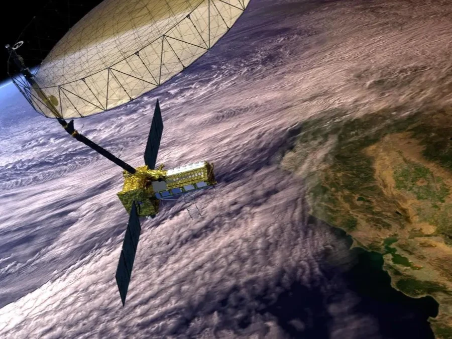
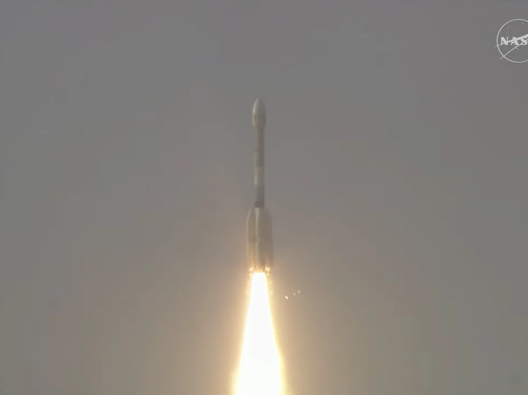
    NASA-ISRO Synthetic Aperture Radar (NISAR) was launched on July 30 from Satish Dhawan Space Centre in Sriharikota, Andhra Pradesh, India. This satellite is equipped with an advanced radar system that will create dynamic, three-dimensional images of the Earth’s surface with remarkable clarity.

    Innovative Dual Payload

    The main structure of the satellite houses engineering systems along with a unique dual payload. It combines a 10-inch (25-centimeter) wavelength L-band system with a 4-inch (10-centimeter) wavelength S-band system, which are each designed to identify various surface attributes. Each system’s signal is specifically tuned to measure different features — including moisture levels, surface texture, and movements occurring on the Earth’s exterior.

    Enhancing Scientific Understanding

    The information collected by NISAR will assist researchers in gaining better insights into the processes related to natural disasters and major events. It will also help in monitoring infrastructure like dams, bridges, and roads. Furthermore, NISAR’s imaging capabilities will be beneficial for emergency responders dealing with hurricanes, floods, and storm surges. The satellite will provide global observations of changing ice sheets, melting glaciers, and thinning sea ice, while also illuminating the effects of deforestation, wildfires, and melting permafrost on the carbon cycle.

    Long-Term Orbit Mission

    NISAR is expected to orbit the Earth for a minimum of three years, scanning almost all land and ice surfaces twice every 12 days. This mission marks the first collaboration between NASA and ISRO on hardware designed for Earth observation, and it promises to greatly enhance our understanding of the planet.

    NASA and Jet Propulsion Laboratory are closely involved in this groundbreaking initiative, aiming to push the boundaries of what we know about our planet’s systems and changes. The collaboration represents a significant step forward in international cooperation for scientific exploration.

    Source:
    Link

  • US-India Satellite Accurately Detects Landslides and Ice Surfaces

    US-India Satellite Accurately Detects Landslides and Ice Surfaces

    Key Takeaways

    1. NISAR is a joint satellite project by NASA and ISRO, set to launch on July 30 or later.
    2. The satellite enhances natural hazard monitoring by detecting small land movements, aiding in disaster management.
    3. NISAR will provide valuable data on climate change effects, particularly in Antarctica, and monitor global ecosystems.
    4. Its capabilities will improve disaster response, particularly for hurricanes and floods, by operating in all weather conditions.
    5. The satellite’s dual-radar system will support agricultural management by monitoring crop growth and soil moisture levels.


    A new satellite, aimed at observing Earth, is the result of a significant partnership between NASA and the Indian Space Research Organization (ISRO). This satellite, named NISAR, is expected to launch on July 30 or later. It aims to tackle major issues in disaster management, agriculture, and climate science by providing a detailed 3D view of the planet’s landscapes and ice, with the ability to detect changes as small as fractions of an inch.

    Enhancing Natural Hazard Monitoring

    NISAR’s key goal is to gather data that could potentially save lives by improving the way natural hazards are monitored. The satellite is equipped with a sophisticated radar system that can identify small land movements, which might indicate a volcanic eruption or landslide is on the horizon. This information will also assist managers in evaluating the safety of important infrastructure such as dams and levees by spotting any dangerous land shifts in the vicinity.

    Understanding Climate Change Effects

    In addition to its other roles, NISAR will serve as a groundbreaking instrument in studying climate change impacts. It is poised to provide exceptional coverage of Antarctica, enabling researchers to monitor the rate at which glaciers and ice sheets are diminishing. With the capability to scan the Earth twice every 12 days, the satellite will compile a comprehensive record of alterations to forests, wetlands, and permafrost around the globe, delivering crucial data for tracking global ecosystems.

    Impact on Disaster Response and Food Security

    The mission of NISAR is also expected to influence disaster response and food security directly. Its ability to penetrate clouds and rain, regardless of the time of day, will help teams respond more effectively to hurricanes and floods. Moreover, the satellite’s dual-radar system is specifically designed to observe crop growth and soil moisture levels, which could enhance agricultural management and food supply predictions.

    NASA’s collaboration with ISRO on this project marks a significant milestone in the field of Earth observation, promising to deliver essential insights for a variety of critical applications.

    Source:
    Link