
Key Takeaways
1. Madinat al-Zahira was established in the 10th century by Almanzor as a political and military center but was destroyed and forgotten after his death in 1010.
2. Researchers from the Universidad de Córdoba used LiDAR technology to potentially locate the lost city, believed to be east of Córdoba at Cabezos de las Pendolillas.
3. The LiDAR data suggests a well-planned urban layout, including rectangular buildings and terraces, aligning with historical descriptions of Madinat al-Zahira.
4. LiDAR technology operates by sending laser pulses to detect changes in terrain, revealing structures hidden underground or obscured by vegetation.
5. No excavations have started at the potential site, and there is currently no timeline for when or if digging will begin to confirm the city’s existence.
Madinat al-Zahira is still one of the big mysteries from Islamic Spain. It was established in the 10th century by Almanzor, who intended it to be a fresh political and military hub. After Almanzor died in 1010, the city was raided and destroyed, then intentionally forgotten. For many years, no one knew exactly where it was located. Over time, many ideas about its location have been proposed, but none have been confirmed with solid proof.
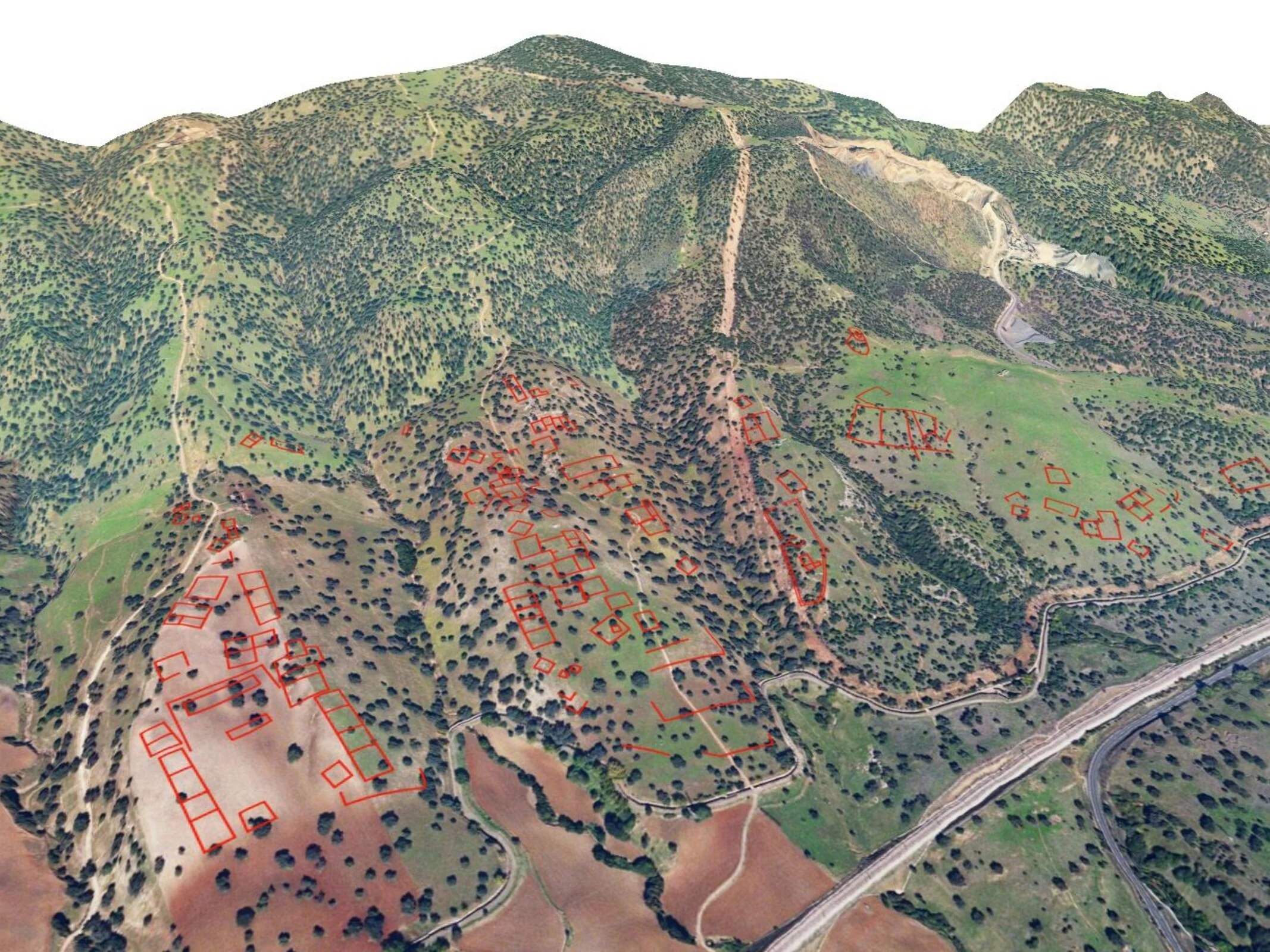
Discovery of Potential Location
A team of researchers from the Universidad de Córdoba (in Spanish) has utilized modern LiDAR technology to potentially pinpoint the lost city’s location, which is thought to be east of Córdoba, in an area called Cabezos de las Pendolillas. The data collected indicates that the site has a meticulously designed urban layout covering approximately 120 hectares, with rectangular buildings, terraces, and a grid-like structure that aligns well with historical descriptions of Madinat al-Zāhira.
How LiDAR Works
The researchers employed LiDAR (Light Detection and Ranging), a technology that many people might associate with contemporary robotic vacuum cleaners. However, instead of mapping out furniture and walls, this system scans the terrain from above. Millions of laser pulses are sent out to measure slight changes in elevation, uncovering structures that are no longer visible to the naked eye. Notably, this method can uncover remains that are buried underground or hidden by plants.
Future Excavations Uncertain
As of now, no excavation efforts have begun at the site, but the sensor data strongly implies that this location could indeed be the legendary city of Madinat al-Zahira. Should this be validated, it would be a significant advancement in archaeology. At present, though, there is no clear timeline for when or if digging will commence.
Source:
Link