Tag: LiDAR technology

  • LiDAR Robot Mower Sunseeker S4: Cuts Grass Up to 10,800 Sq Ft

    LiDAR Robot Mower Sunseeker S4: Cuts Grass Up to 10,800 Sq Ft

    Key Takeaways

    1. Sunseeker is expanding into the European market and introduced the V3 series and X series of robotic lawn mowers last year.
    2. The Sunseeker S4 model is set to launch in 2026, priced at $1,599, with preorders available and deliveries starting in March.
    3. The S4 utilizes LiDAR technology instead of an RTK antenna for mapping and obstacle avoidance, following a trend among other brands in the industry.
    4. Key features of the S4 include a 360-degree LiDAR sensor, AI camera, automatic mapping, and edge-following mode for efficient lawn care.
    5. The mower can handle yards up to 10,800 square feet and manage slopes of up to 42% (22 degrees).


    Last year, Sunseeker revealed plans to break into the European market. During that announcement, they also unveiled the V3 series of camera-based robotic lawn mowers and the X series, which includes RTK mower robots.

    Upcoming Models in 2026

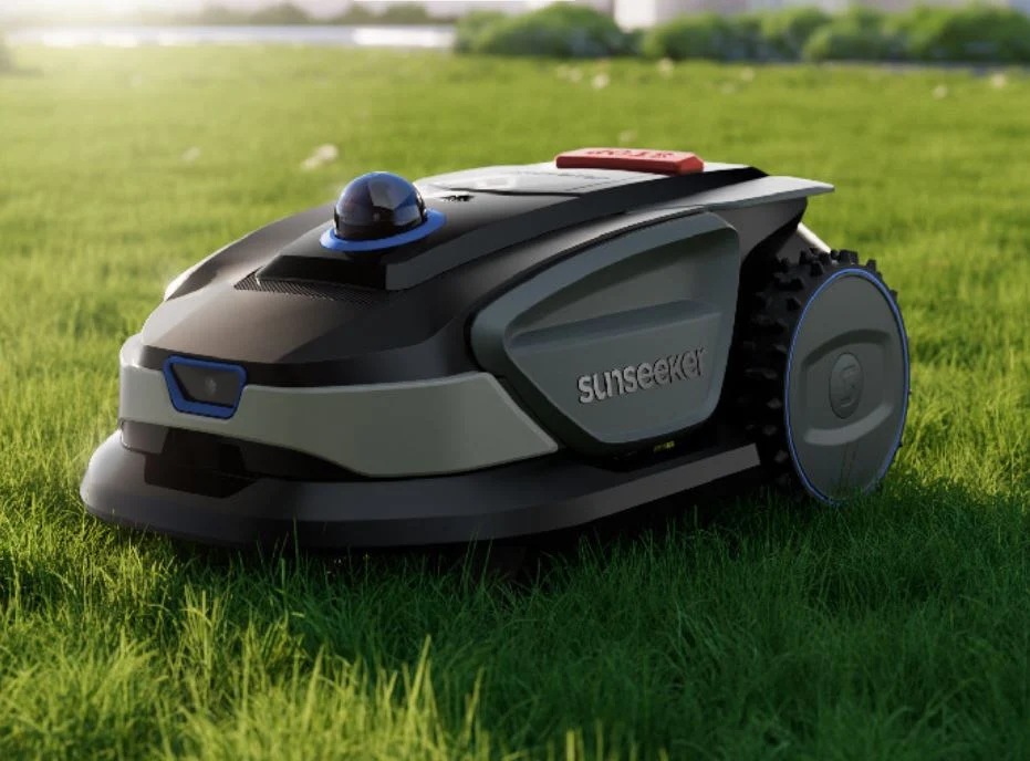
    Looking ahead to 2026, more models are expected to be added to the company’s offerings. They have already confirmed the Sunseeker S4 and even displayed it at CES 2026 in Las Vegas a few weeks ago. The new robot mower’s official release seems to be just around the corner, as it is already available on websites like Amazon. Specifically, it is priced at $1,599 and can be preordered now, although deliveries in the US won’t happen until March 10. It remains uncertain whether this price is a special launch rate or the standard MSRP.

    Technology Used in the S4

    What stands out is that the Sunseeker S4 does not use an RTK antenna; instead, it relies on LiDAR technology. This aligns with a growing trend among various manufacturers who are also adopting this tech, which is mainly recognized from robotic vacuum cleaners. In the lawn care space, brands like Dreame, Mova, Roborock, Navimow, and Ecovacs have already embraced LiDAR. Regardless, the S4 combines a 360-degree LiDAR sensor with an AI camera, branding this as the “Allsense 3D Sensing System,” which promises precise mapping and effective obstacle avoidance.

    Features and Capabilities

    In addition to radar-based automatic mapping that comes with a “Drop to Go” function, the Sunseeker S4 is capable of handling yards up to 10,800 square feet, or about 0.25 acres. It also includes features like an edge-following mode for trimming along borders and dual map storage for managing different lawn areas. To top it off, it can manage slopes of up to 42% or 22 degrees.

  • LiDAR Reveals Ancient Lost City After 1,000 Years of Mystery

    LiDAR Reveals Ancient Lost City After 1,000 Years of Mystery

    Key Takeaways

    1. Madinat al-Zahira was established in the 10th century by Almanzor as a political and military center but was destroyed and forgotten after his death in 1010.
    2. Researchers from the Universidad de Córdoba used LiDAR technology to potentially locate the lost city, believed to be east of Córdoba at Cabezos de las Pendolillas.
    3. The LiDAR data suggests a well-planned urban layout, including rectangular buildings and terraces, aligning with historical descriptions of Madinat al-Zahira.
    4. LiDAR technology operates by sending laser pulses to detect changes in terrain, revealing structures hidden underground or obscured by vegetation.
    5. No excavations have started at the potential site, and there is currently no timeline for when or if digging will begin to confirm the city’s existence.


    Madinat al-Zahira is still one of the big mysteries from Islamic Spain. It was established in the 10th century by Almanzor, who intended it to be a fresh political and military hub. After Almanzor died in 1010, the city was raided and destroyed, then intentionally forgotten. For many years, no one knew exactly where it was located. Over time, many ideas about its location have been proposed, but none have been confirmed with solid proof.

    Discovery of Potential Location

    A team of researchers from the Universidad de Córdoba (in Spanish) has utilized modern LiDAR technology to potentially pinpoint the lost city’s location, which is thought to be east of Córdoba, in an area called Cabezos de las Pendolillas. The data collected indicates that the site has a meticulously designed urban layout covering approximately 120 hectares, with rectangular buildings, terraces, and a grid-like structure that aligns well with historical descriptions of Madinat al-Zāhira.

    How LiDAR Works

    The researchers employed LiDAR (Light Detection and Ranging), a technology that many people might associate with contemporary robotic vacuum cleaners. However, instead of mapping out furniture and walls, this system scans the terrain from above. Millions of laser pulses are sent out to measure slight changes in elevation, uncovering structures that are no longer visible to the naked eye. Notably, this method can uncover remains that are buried underground or hidden by plants.

    Future Excavations Uncertain

    As of now, no excavation efforts have begun at the site, but the sensor data strongly implies that this location could indeed be the legendary city of Madinat al-Zahira. Should this be validated, it would be a significant advancement in archaeology. At present, though, there is no clear timeline for when or if digging will commence.

    Source:
    Link